Pat's Paddling Guide to Corsica
Pat Thoyts
Contents
- Introduction
- About this Guide
- Grading Rubbish
- Other Guides in this Series
- About the Author
- The rivers:
Paddling in Corsica
Why?
Why do we do any of this? You know how it goes, you were sitting around in the pub in Wales one night yarning away, when some bright spark says "I dunno about the Alps again, how about somewhere else?" Then some other drunken sot says something along the lines of, "I heard Corsica was supposed to be pretty good." Later, once the hangovers lay off mugging your brain, you hopefully forgot all about it. If you didn't, then I guess that's why you're looking at this booklet! If you end up on Corsica, just remember why you went, and whose idea it was in the pub. You can probably still kill him now!
Corsica is the place to go for continuous hard paddling. When the guide books say a river is grade V they mean the whole river runs at that grade! We have found that for a grade V Corsican river you can expect to take at least 1 hour per kilometre. I know the Germans do it faster, we met one guy coming off the Vecchio after a 5 hour epic, and he said it only took him and hour or so. But then, we also wondered where his mates were. It took a while to gather he'd done it on his own! Says a lot really. This time also assumes that you inspect pretty much everything from the boat, and make your mind up quickly. No standing around trying to work up the bottle to run a drop. You must paddle or portage fast, unless you fancy a nice paddle in the dark! In which case, don't forget your Petzl.
When?
The time to be out in Corsica is over Easter. This can provide mixed weather so you need to be prepared for extensive rain. If it stays sunny it can be about as hot as the Alps in the summer. At night however, especially in the mountains (e.g. Corte) its likely to get pretty chilly. Don't take a summertime sleeping bag!!
How?
Getting to Corsica is a bit more involved than the average trip to the Alps. Book the Corsican ferry early or you may be forced to go to odd ports. Apparently the ferries from the French mainland book up really quick. We were advised to book not much after Christmas. We actually booked 4 weeks before we wanted to go and this forced us to leave from Livorno which is a much bigger drive from the UK. In 1991 the Livorno to Bastia ferry was Ł35 for a car and Ł15 per person each way. The UK address for all the ferries from Italy is Viamare Travel Ltd,Graphic House, 2 Sumatra Road, London NW6 1PU Tel:071-431-4560 Fax: 071-431-5456The French ferries (SNCM Ferries) are run by Continental Shipping and Travel, Tel: 071-491-4968. In 1993 their prices were Ł32 each and Ł40 per car, with Ł9 for a bunk. The crossing is also 12 hours, i.e.: overnight.
The Livorno crossing is 4 hours, and Livorno is about 6 hours from Briançon. However, the French ferries are a lot more expensive, and it probably is actually worth the extra driving. Also, as the Livorno ferry leaves on Monday afternoon, we drove down to the French Alps on Friday night and Saturday. Spent Saturday night in Valloise campsite (which is shut, but what the hell) and did some skiing and Sčrre Chevalier on Sunday, leaving for Livorno on Sunday night. The days break makes a big difference in the journey and skiing usually provides lots of wipe outs for everyone to yarn about too!
As for getting back, on the 1993 trip, we converted from the return to Livorno on Saturday morning from Bastia, to a ferry to Genoa on the Friday for not much cash. This it think is a better option than a return trip to Livorno, as you get to skip out a large chunk of Italy whilst only adding two hours sitting on a ferry, and also you get to do you supermarket shopping in France on the Saturday, instead of carting all your goodies up from Corsica. I think this will be worth another go.
Where?
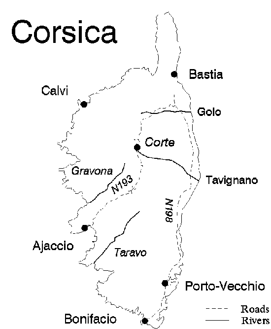
The best place to be for more than one day is Corte. Its the only central point for the whole island. There are lots of rivers you can't do from here, but quite a few are easily accessible e.g.: Golo, Asco, Vecchio, Tavignano, and Restonica, and maybe the Fium Orbo.
Camping
Campsites are fairly common, although a few were not yet open. Bivi spots are widespread too. Buying food is easy on the coastal plain and the big towns, but can get hard elsewhere. In the big supermarkets connect cards are OK just as in mainland France. The same is true for petrol. Bread is pretty much everywhere.
Upon Arrival
This bit up to you, of couse, but we found that as you arrive on the island at around six p.m. you don't have long to spot a campsite, so by default we found one near Bastia. As it's so nice we use it any time we need to go near Bastia now. Its handy for the night before departure too as it close enough to make the 8.30 am depature not too arduous.About this Guide
The main purpose of this guide is to provide a current and easy to produce canoeing guide for the club. I first went to Corsica in 1992, and again in 1993, and I also have some information from Jules and Johnny Earle from their trip in 1990. Obviously things change from year to year and you need to be aware when paddling. If something has changed, a new barrage, or a landslide etc., then don't sit around whinging, write it down and tell me about it later, and it'll be correct in the next guide!The guide has grown a bit so I had to split it into areas. I now have French Alps, Corsica, Austrian Alps and minor notes for Italy, Chile and British Columbia, and maybe Norway if Dickie ever gives me his notes.
Each river has a header telling you, after the name of the section, how long the described section is, what the general grade is, how long it took us to paddle it and which year I last paddled it. The year is partly for my own sake, and partly because I was asked to indicate clearly when the information on that river was last updated. {92} means I paddled it in 1992. {} means I never paddled it at all, and its all hearsay. {92} is used to mean that someone I trust and know well paddled it in 1992 and I consider the info to be accurate.
The maps have been copied from 1:100 000 maps and scanned into the computer. The style owes much to Joseph Haas as I like his maps for their clarity. In fact, for Corsica I'd recommend getting hold of a copy of his guide anyway. Its excellent.
If you have any comments, complaints, or if you do a river that's not in here, please tell me about it! Either through the BUCC at B.U.C.C., University of Bristol Students Union, Queens Road, Clifton, Bristol, UK. Or through the internet - in which case refer to my contacts page
Grading
These should give a fair idea of whether or not you can expect to get down the river. Here are what I think each grade means, plus an example of each.
- Grade I EASY
- Regular flow, regular waves, little swirls, easy obstacles.
You should not leave the car.
e.g.: River Avon at Saltford- Grade II MEDIUM
- Quicker water, easy obstacles, obvious routes
You should only leave the car to laugh at the nobbos.
e.g.: Symonds Yat on the Wye- Grade III DIFFICULT
- Swift current, short stretches of difficult rapids. Route may be obscure.
You should be paddling a comfortable boat, so you can snooze.
e.g.: The Dart, Middle Trisanna - Grade IV VERY DIFFICULT
- Long stretches of unbroken rapid, very fast or heavy water. Previous inspection likely. Very difficult route through the rapid. You should take some spare underwear, just in case. e.g.: Llangollen Town Falls, Spean Gorge, Sanna
- Grade V SEVERE
- The worst waves, whirlpools and rapids. Narrow routes, very high or obstructed drops, difficult to get in or out. Take spare underpants in your BDH. Tie the BDH to you so it's still with you when your boats smashed. e.g.: Easn Dubh (Orchy), Triple Step (Guil), Falls of See (Trisanna)
- Grade VI EXTREME
- Impassable most of the time according to water level. Very hazardous rapids, badly obstructed drops. Put your clean kacks on and go to the tea shop. e.g.: Swallow Falls, Gyronde Portage, Slot (Guil), Ardez Gorge
- Grade VII VERY EXTREME
- Very high and obstructed drops, often close together, frequently shallow plunge pools. Serious danger to life. The tea shop was closed and someone stole your kacks. e.g.: Conwy Falls, Llanberis Falls, Upper Restonica
The Rivers
Asco 12km Grade IV(V) {}
Easily reached from Corte, but frequently low as the snowmelt for this river comes from Corsica's highest snowfield. This is best looked at late in the season I would guess. We had a look before and after some rain but it didn't appear to make any difference. We reckon if it looks too low at the bridge where the D147 crosses the Asco then it will likely be rubbish further up as well. It is apparently a favourite starting river for those arriving via Bastia. Steep boulder strewn river which could be great fun.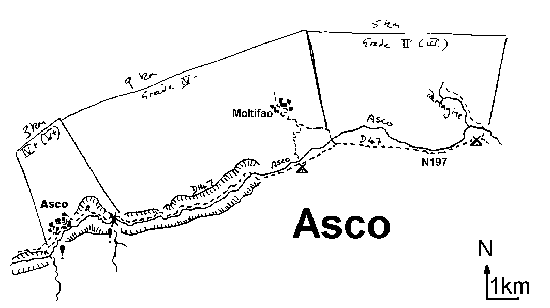
Cassaluna {90}
Looked at river from the first bridge (2.5km up the D39). It was tiny. We didn't look any further.Upper Golo 8km Grade V (VI) 5.5 hr {90}
Egress at the bridge above Albertacce (gauge here read 190cm, but really needs 230). The Calisima can be seen coming in from above, the Golo sneaks in from the left. We were told the Calisima was unrunnable (no water). Work out which river has water in it! Access to the Golo is at Maison forest de Poppaghia. Walk down an open forest track then scrape down a tiny stream for 40 minutes. Alternatively, walk to the confluence where the river becomes deserving of the title. This is the start of the fun. Narrow gorges, chutes, and big weir type stoppers lay ahead. You will bounce round a right hand bend and find yourself in an impressive parallel gorge. The next thing you notice is that a huge chock stone, about 3 metres across blocks the river ahead. Next you'll notice that an awkward climb out is awaiting. Get out before the gorge! Get back in where your confidence allows (there is a good combination drop at the end.) There are about 5 portages. An entertaining river with good epic potential.NOTE: The Scala di Santa Regina gorge was dry and the lake at the top looked about 25 foot low. We nearly didn't go any higher.
Middle Golo 12km Grade II-III {93}
From Ponte Castirla to the road bridge to Casaluna. This is the section with the famous ‘Vacuum Cleaner stopper’. I can't say I've found it very impressive yet though. Mostly it's Grade II-III with just the one biggish fall, as mentioned. We did it after a night of pissing rain and it was a good fun play river, but the Vacuum cleaner was still disappointing! The gauge at Castirla was broken but I estimate it at about 40cm, or maybe 1.40. Anyway, it was obviously paddleable at the get-in. The gauge at Albertacce was 210.Lower Golo Gorge 11km Grade III+ {93}
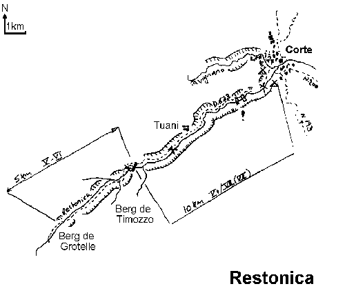
From the Barchetta road bridge to a sort of weir by the road about 11km down. Its quite a good begginers river, posessing long stretches of flat moving water with the odd fun rapid. Its not great but would be fine as a starting river as we did it. Don't do it at the end of a trip, or you won't appreciate the fine scenery! We had one portage around a large weir, no inspections necessary. A gauge at Pont Luccia was about 80cm, but its a crap gauge!Restonica up to 10km grade V+ (VI-VII) {90}
Heh heh heh heh! The first time I got on this river I managed 2km and it tok us3 hours. We got in at the bridge to a caampsite, half way up the valley. We got out about 4 hours later at the first of the two small weirs you can see from the road 2 km downstream. Allowing for faffing as McNally managed to lose a pair of blades to an undercut boulder we did 1˝ hours a kilometre! In this stretch were two portages, and one other which we probably should have carried too! It's very continuous but we didn't find it to be as overgrown as described by Simon Dawson, more like going down a cosmic pinball machine with water added. We did it in spuds but we were joined by a mad German on his own who was paddling a T-Canyon with a mate on the bank in a wetsuit to pull him out when he got pinned, so it can be done in a bigger boat, honest! As for waterlevel, I don't know as we couldn't find any guages. If it looks remotely like you could get a boat down then go for it. We tried to measure the level at the get-in on the iver right bridge pillar, on the downstream side the water was 50cm below the concrete top.We later did the section above, from the next bridge upriver down to the get-in above. This wasn't quite as much fun as there were slightly more rocks to water than the lower section, but it was still very continuous with the same impressive gradient. More water here might have been nice, but too much...eek! There were no protages but one medium sized weir had some spikes and concrete in it so we seal launched on the right down a rock slab. This stretch of 2km took us 2˝ hours.
All in all, a very interesting river, which can fortunatly be looke at extensively from the road. The gorge before Corte is supposed to go OK, but it looks a bit evil from the road. Possibly it could be more accurately scouted from the other side where a path goes up quite a long way from the campsite there. The map here is a bigger scale than I really want, I'll get there later!
Lower Tavignano 18km Grade IV- (IV+) 2˝hr {93}
We got in at some roadworks by Pont di Pied Corte. Grade II-III down to a brand new barrage (immediately preceded by a 10 min grade I paddle over the small lake). About 1 km after the barrage the river gorges up to III (IV) and gets quite tight in parts. After an old bridge close to one of the N200 bridges is a gauge in a pool down stream of the old bridge on river right. We paddled this at 212cm, and couldn't find this gauge from the road. Get out just after the second N200 bridge on the left, before Fiao, and follow the obvious track up to a lay-by.In 1993 the guage was 235cm. No worries and only one inspection.
Upper Fium Orbo5km Grade V (VI) 5hr {93}
The gauge at the top of Gorge du Strette read 135cm, 145cm would be much better. Access is at Cavu, by driving through the village and down a really crap dirt road. Low water again meant finding the river hiding in the boulders. Some good chutes, and most can be inspected from the boat. A slow portage begins before a footbridge made of RSJ's. You really do want to get out here! The canyon which follows has some large waterfalls/chutes which can be run if you have a lot of time and a suicidal approach to life. We ran the first after the portage (the Rocket in Haas' guide), but watch out for the wall on the right, we had a swim from this! The rest of the gorge can be run, but is probably grade VI. A difficult climb down to the river after the canyon awaits you. Oddly enough, the footbridge connects with a footpath which leads to the road (this may be handy!) From here on, many inspections are necessary at any water level and there is at least one portage over big boulders on the right avoiding an evil slot on river left.We managed to do this in a day from Corte and found the drive over the col only took an hour. In 93 the guage was 160cm which was a good levelfor eveything, except the 'Rocket' which was washing out of the pool too fast and thus the protection was going to be a pain to set up.
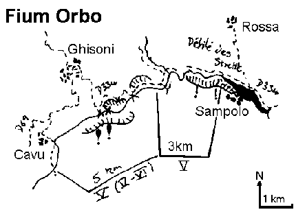
Fium Orbo - Defile du Strette 4km Grade V 3-4hrs {93}
Ran at 135 on the gauge 50m from the get in. This is a bit low again, it is supposed to be better at 160cm. A short section, but possibly too much to combine with the upper section unless you plan well. Everything can be portaged. One impassable chute requires an outstanding seal launch to get back into the river. Good fun afterwards, but make sure you slide forwards into the pool rather than backwards into the slot behind!!Ha! Did this at 158cm, a superb level! There are 2, maybe 3 portages and at this level it took us 3-4 hours. A great paddle, marred by the fact that some bastard broke into the car which was at the bottom by the bridge. I don't know what you can do about this. We met an Italian who had covered one of his windows with tape and plastic bags to make it look as if he'd been broken into already! I guess it might help?
Travo {90}
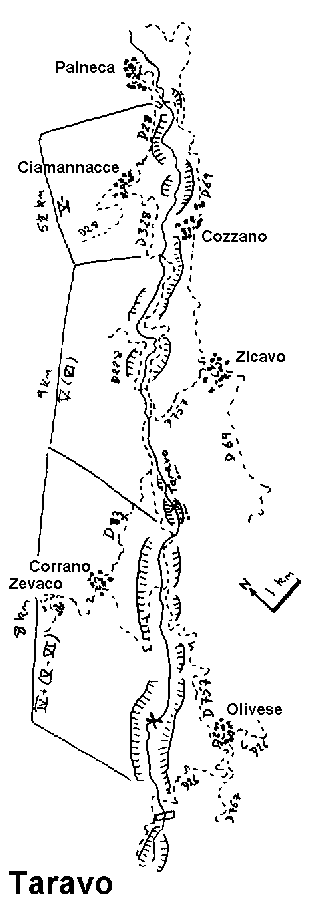
We were very disappointed to find no water here. The level was about a metre below the metal plates down near the river mouth. A large party of Germans camping at the egress confirmed that the river was unrunnable. Next year maybe.Upper Taravo 9km Grade V (VI) 4- 5hrs {92}
You can get in at Palneca if the water is high enough for 5.5 km of grade V-. Otherwise get in at the D328 road bridge. There is a gauge above the D757 road bridge in the gorge (also the get out if you can't cope with the gorge). This was 135cm when we paddled and at this level the large and fairly continuous boulder gardens were irritating, especially for those in longer boats. Every so often there are some quite difficult drops to inspect, most of which can be run. We did 2 portages. After you pass the D228 road bridge the river flattens out becoming grade III and a bit scrapy at this level.Some way down the river is the gorge section. This can be run as two sections. The first warrants a look from the bank at the last drop which can't be inspected from the bottom of the gorge, and can't be portaged once in the gorge. Run it left to right to avoid the heavily undercut wall after the drop (a good 2m!)
The second gorge section can also be run but again deserves a look from the bank before you enter the gorge. The only way out if you don't like it is up the framework holding the gauge in place! The first drop in here looks to have an interesting siphon, but you can chicken shoot it entirely by sliding down the rock shelf on the far right. Get out below the bridge.
There's a good bivi spot by this get out.
Rizzanese 7km Grade V(VI) 8 hours?? {}
We didn't get round to doing this one, but it has to be the most famous river on the island. Supposedly to be done when low water conditions exist. Don't do it if it's wet as the rock becomes very slippery, and do allow a lot of time i.e.: 8 hours.You get in at the D20 road bridge near Zoza where there's a gauge to inform you just how bad it's going to be. Good levels are between 60cm and 95cm. You can also warm up on the 1.5 km just above up to an unrunnable fall. There's an HEP works to portage somewhere early though! The river starts off IV and soon increases to V with a couple of portages, first carry left, then carry right.. A wide sloping 6m ledge marks the start of the hard stuff. 100m below are two falls to check, 3m and 10m, on the left? The 10m fall has a rock in the bottom on the left and so is usually shot extreme right. I have heard that this quite often produces injuries though, and you might want to treat the drop with special care.
The rest of the river is quite hard with two bad drops, one of which kills people (6m drop into a boily pool), chicken shoot to the right. From near this drop its possible to hop out onto a footpath near the N194, but, time and energy permitting, you can go on a bit for 8 km of grade III to wind down and get out at the D69 road bridge below Arbellara, or the Genoese bridge 2-3 km further down.
There's a campsite near this bridge.
Gravona 12km Grade IV (V) 3˝hr {93}
Access at the bus station lay-by near Costeglia, or the D129 road bridge for a slightly shorter run. Exit at the D1 bridge, which is after a railway bridge! The gauge here read 70cm (it was just the same at 60cm, 70 was better). From the bus station to the D129 is very woody, but stick with it and it improves after the bridge. A natural slalom course amongst large boulders, generally tame. One probable portage where a steep rapid cuts diagonally right against a wall (made to look easy by one member, skipped by the others!) Shoot the large weir (6 metres) centre right. It's much more fun once you've done it! The river gets woody towards the end again. Not an outstanding river by Corsican standards, but OK.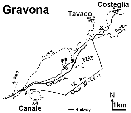
Cruzzini - Lower Gorge 6.5 km Grade IV (V) 2.5hr {90}
The gauge at Pont de Truggia cannot be seen from the bridge, but is 100m upstream on river right. It read 140cm. Access is where the D125 drops down near the river after Lopigna. This is a slow part of the island to get around and Vico is the only place with food. Pleasant river, no portages and about 3 inspections - so nothing too tricky.Liamone 10 km Grade V (VI) 5hr {93}
The gauge is at Pont de Truggia, but it seems to have been washed away! At 140cm there are lots of inspections (5'ish). At the get-in there is a gauge rock mentioned in the Haas guide. Its a flat rock upstream of the bridge in the centre of the river. We most recently ran the river when the water was just barely washing over the top of th rock. In general a little more water would have been good, this might correspond to a level of 1m on the Pont Truggia gauge.A large volume river with big stoppers and holes and heavy boulder fields. At 1m its less fun, more of a rocky, technical grade IV (V). Watch out for one dodgy drop a fair ways down. A good percentage of the river goes under a big boulder. It can be run safely on the left but the lead in drop has some rocks in the landing. A fairly open river until the main gorge section. This begins with a definite portage and then a bloody difficult walk high along the river right side. Rejoin the river with a seal launch from an obvious platform (lower the boats down). Alternatively we were advised to cross the river after the first fall and portage on the left bank to another seal launch. Getting up is a bit of a climb but much easier than the other side and from this bank inspection of the gorge is possible. We saw the gorge run, and it didn't seem as difficult as it appeared (at least in a Gattino), but it is run blind - one of those situations where you would hardly be surprised to come over the lip of the first fall and see your chums stacked up below you. A bit after there's an interesting 2m natural weir which may entice you to a superb stuffing!
The car shuttle takes around 80 minutes (65 min if you have some maniac drivers with you), walking out of the river can take over 2 hours without a boat. Definitely a river to tick, "It's big, bouldery, exciting, and horny."
Fiume Grosso and Upper Liamone 8.5km Grade V (VI) 8hr {90}
Access is at the bridge by Bains de Guagno, and egress is at the Pont de Belfiori. One helluva river. The level was about 6 inches above the vague Haas guides "slightly covered rock" mark. It continued to rise while we were on the river. The 8.5 km took 8 hours to complete. Start early or finish in the dark (not recommended). There were somewhere between 6 and 10 portages, 2 or 3 of these looked impossible, others looked to have uncertain outcomes. We made upwards of 20 inspections - don't spend too long making up your mind. This was a continuously hard epic. At this level the steep boulder fields and ledges produce powerful stoppers and holes. Walking out is impossible, and some of the rapids must be run.Fango 3hr {90}
A very scenic open gorge type of river. Some enjoyable little drops. Well worth a visit at the start of the holiday if you are near, probably too tame for the knackered mega-hero on his way home! We put in at Manso due to low water. Run the bit above the road bridge for a quick start. Beautifully clear water.Middle Vecchio 7.5km Grade V (VI) 5-6hr {93}
One of the classics. We ran this when the gauge at the bridge to Nochetta read 1.55cm. The recommended level is 160, above 180cm and below 140cm the river is probably risky. The river goes far from the road and walking out is more a case of walking along the river. The access point is at Pont Vecchio, a large railway bridge with the N195 passing under it (about 30 min from Corte). There is a steep walk down to the river from the bend near a lay-by south of the bridge. Much of the time you pick your way among large (Corsican) boulders, it's a classic (the classic) drop pool river. We did 4 portages and the trip still took a very long time. We also manage dto watch people doing most of our portages! The second time I did this we seem to have swapped a portage somewhere, still ending up with 4. Look out for pinning between rocks if paddling at low water levels (e.g. 140). The first serious portage appears as soon as you can see a broken footbridge above the river about a kilometre from the start. Portage on the left. There's a good bivi spot near the get out, up on the right bank.
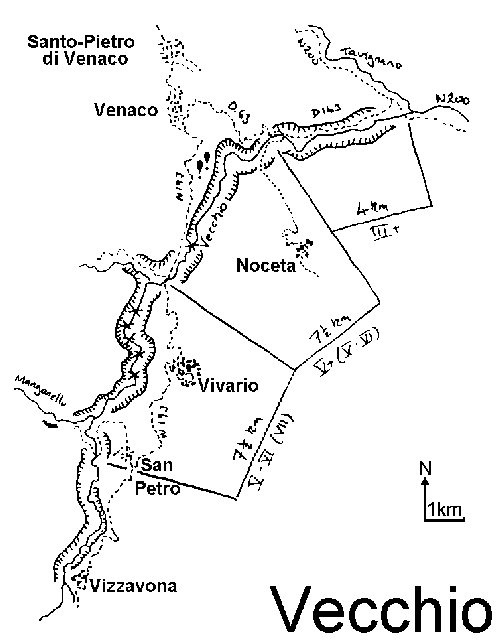
Lower Vecchio 7km Grade III
We got in at the Nocheta bridge, the get-out for the Middle section where the gauge was 158cm. A fun bimble without too much scrapy bits. We got out at the bridge over the Tavignano. You could perhaps get out at an earlier bridge at the Vecchio-Tavignano confluence.
Back to the Contents PageOther Guides in this Series
- The Austrian Alps, last updated 1993
- French Alps, last updated 1994
Pat Thoyts thoyts@bsa.bristol.ac.uk
Copyright © 1989, 1993, 1995 Pat Thoyts
The right of Patrick Thoyts to be identified as the author of this work has been asserted by him in accordance with the Copyright, Designs & Patents Act, 1988
Back to the Contents Page